Imagen

The official map of Torrevieja's new urban transport network has been presented, featuring eight lines connecting all neighborhoods and urbanizations in the municipality.
The new map makes it easier for users to identify routes, stops and connections for a service that will begin implementation this summer.
13.07.2026
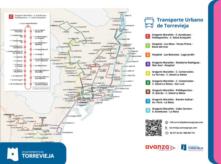
The network connects hospitals, health centers, shopping centers, sports facilities, the bus station and the main residential areas of the municipality
The Torrevieja City Council and the concessionary company AVANZA have presented the new official map of the urban transport service, a tool designed to facilitate the use of the bus by residents and visitors and which will allow them to know at a glance the route of all the lines, their main stops and the existing connections between the different neighborhoods and urbanizations of the city.
The new map, created with a clear and intuitive design, represents the eight lines that will make up the new urban transport network, differentiated by colors and accompanied by an individual diagram of each route, thus facilitating the planning of daily journeys.
The network is structured around a main axis located on Doctor Gregorio Marañón Avenue, from where most of the routes to the different areas of Torrevieja depart, guaranteeing better connectivity with the main public facilities, health centers, shopping areas, sports facilities, the bus station and the beaches.
ONE CIRCULAR LINE AND SEVEN LINES CONNECTING THE ENTIRE MUNICIPALITY
The new network will consist of the following lines:
-Line C (Circular): will run through the urban center connecting Doctor Gregorio Marañón Avenue with the Bus Station, the Municipal Sports Centre and the Acequión Health Centre, becoming the line with the highest frequency for internal journeys.
-Line 1: will connect the University Hospital of Torrevieja with Los Altos, Punta Prima and Rocío del Mar.
-Line 2: will link the Hospital with Los Balcones and Lago Jardín.
-Line 3: will connect Doctor Gregorio Marañón Avenue with Desiderio Rodríguez, Mar Azul and the University Hospital.
-Line 4: will connect the urban center with the shopping centers, La Torreta and the La Siesta Health Center.
-Line 5: will extend the service from the center to San Luis, also passing through the shopping centers and the La Siesta Health Center.
-Line 6: will link the center with the Municipal Sports Centre, the Quirón Hospital, the International Auditorium and the La Mata Health Centre, also incorporating a special service to the market and the Auditorium during the celebration of events.
-Line 7: will connect Doctor Gregorio Marañón Avenue with Ramón Gallud, Paris Avenue and La Mata.
-Line 8: will connect the center of Torrevieja with Cabo Cervera, the Bus Station and La Mata, reinforcing the connection of the northern coast.
A PLAN DESIGNED TO FACILITATE THE USE OF THE BUS
The map includes the location of all stops on each line, identified by their corresponding code, as well as the complete list of round-trip routes. It is available in both print and digital formats via a QR code that provides access to all updated service information. It also includes customer service phone numbers and the website for urban transport information.
With this new service mapping, the Torrevieja City Council continues to advance in the implementation of the new urban transport contract, which will allow for a more modern, accessible, efficient network adapted to the significant population growth experienced by the city, improving mobility between the different neighborhoods, urbanizations and main points of interest in the municipality.